HomeServicesGeographical Information System

Organize · connect · understand

Geographical Information System (GIS)

Enterprise GIS foundations that turn dispersed spatial data into secure, connected and decision-ready information.

From data to shared intelligence

Build a GIS environment around the way your organization works.

MipMap designs the architecture, migration and application layers as one system. The result is a reliable spatial-data environment that people can securely access, update, analyse and share — in the office, in the field or through the cloud.

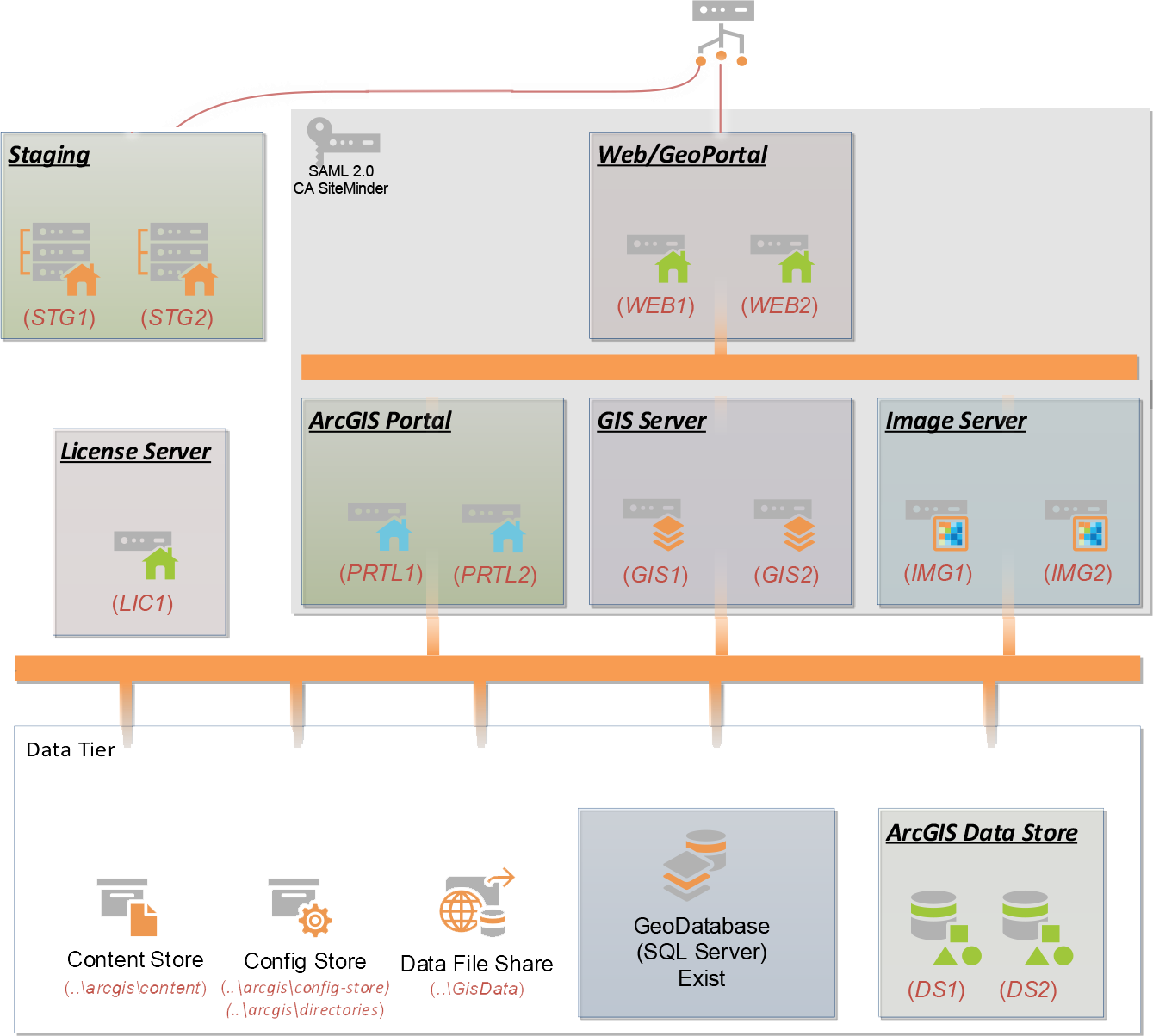
ArcGIS Enterprise installation and configuration architecture
A stable enterprise foundation

Install & configuration

Tailored ArcGIS Enterprise architecture enables controlled data management, sharing and remote access. MipMap configures the core platform around the organization’s security, availability and performance requirements.

Portal for ArcGISGIS ServerWeb AdaptorsData Store
  • Portal and Server site creation
  • Web Adaptor, SSL and WebContext configuration
  • Data Store registration and server federation
  • Production-ready access and publishing workflows
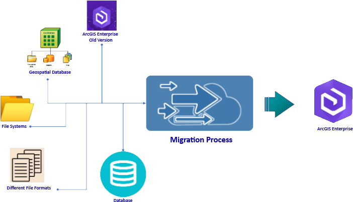
Spatial data migration process
Move data without losing meaning

Data migration

System upgrades, cloud adoption and organizational mergers all require careful migration. MipMap analyses the existing data model, volume, quality, formats and system relationships before defining a controlled transition plan.

01AssessInventory, quality and dependencies
02TransformClean, map and validate
03MigrateLoad, test and reconcile
Proven at utility scale

Experience includes approximately 13,500 km of water and wastewater surveys in Jeddah and 3,000 km of utility surveys in Makkah.

GIS system integration and software development
Connect the whole information landscape

System integration & software development

GIS becomes more valuable when it can exchange information with operational, analytical and business systems. MipMap develops the interfaces and applications that join spatial workflows to the wider technology environment.

GIS databasesCustom softwareIT infrastructureBig dataBusiness intelligenceData warehousesCybersecurityMobile analysis

Solutions can be delivered as fully managed services, from architecture and implementation through ongoing technical operation.

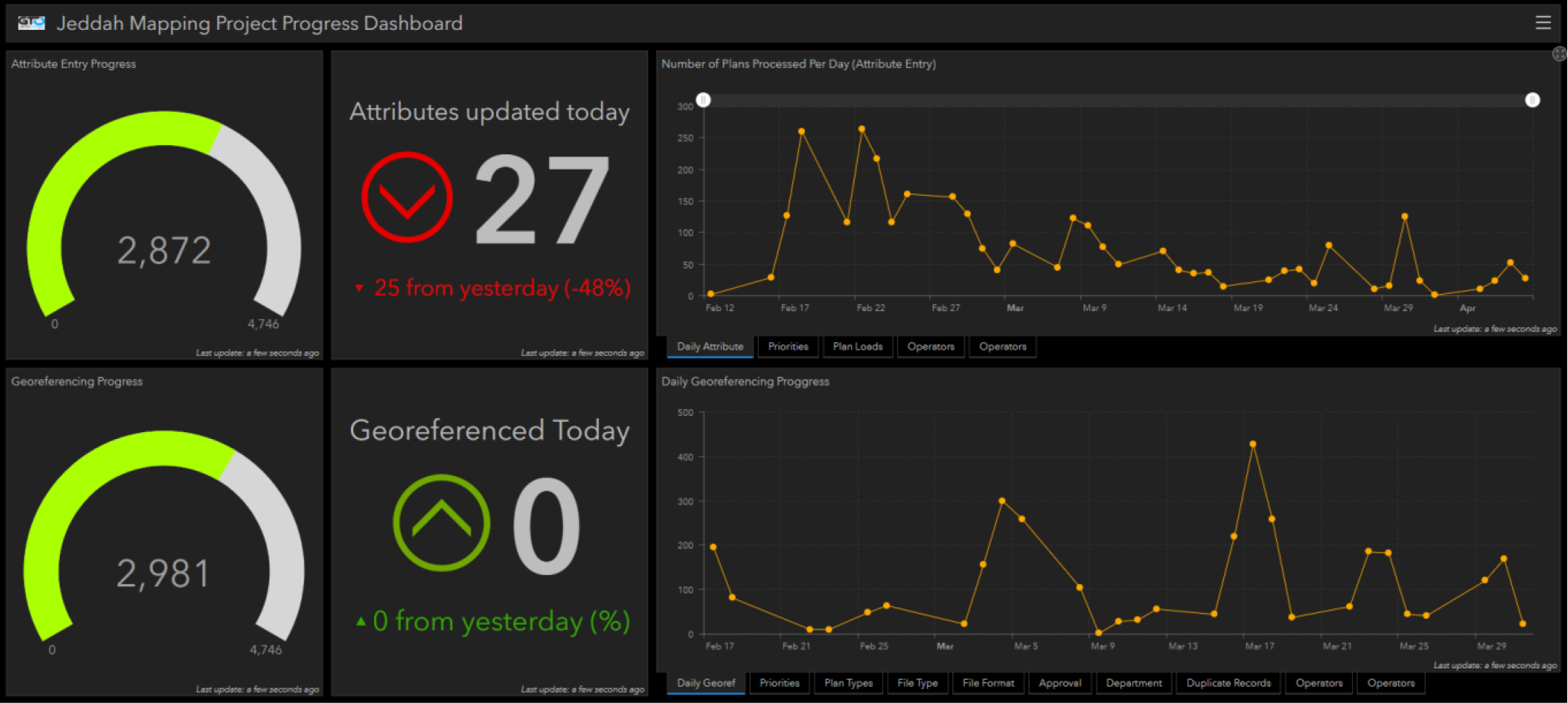
Customized ArcGIS project progress dashboard
Tools shaped around the workflow

Customized ArcGIS applications

Existing ArcGIS applications can be extended with purpose-built add-ins, plugins, widgets and dashboards. Instead of asking teams to adapt to generic software, the interface is aligned with the data, roles and decisions of the real workflow.

  • Role-based dashboards and operational views
  • Custom editing, validation and reporting tools
  • Web, mobile and field-workflow integration
  • Clearer analysis, collaboration and decision-making
A GIS built for use

Connect your spatial data, systems and teams in one trusted environment.

Talk to our GIS team →