
Multi-Scale Digital Twin


.jpg)
3D Buildings Generation
As MipMap, we can produce 3D buildings at LOD1, LOD2, LOD3, and LOD4 levels.
LODO
Building footprint, best with simple maps or 2D analyses. There is no height attached to it and no parts of the building are visible.
LOD1
An extension of LOD 0 footprints to include height information.
LOD2
Roof shapes are the most significant improvement for this mode. Such models can be generated in real time from polygons of the footprint, values for the height.
LOD3
Covers maximum roof detail and includes facade detail. There is no limit to the amount of information that can be included.
LOD4
All types of surfaces (floor surfaces, internal and external wall surfaces, etc.), additional movable, and immovable building elements (balconies, chimneys, etc.) are further detailed as semantic objects.


3D Mapping & Generation of City Furniture
The purpose of 3D mapping is to produce seamless 3D topography/terrain, buildings and other structures required for rational planning, project implementation, operation, maintenance, cadastral/management and other geospatial activities.


As Mipmap, we can seamlessly combine a variety of high‐end tools, including automated feature extraction, AI-based visual corrections, rapid rooftop modeling, and 3D model exporting.
MipMap provides innovative solutions that demonstrate knowledgeable expertise in state-of-the-art technological work related to 3D reconstruction, 3D model generation, rendering and understanding of the intricacy of the 3D modeling process.

With MipMap, you can have 3D city models that can perform precise analyses in months, not years.
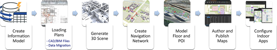
Indoors Mapping
Indoor mapping visualises an indoor location and spatial data on a digital 2D or 3D map, enabling solutions such as Indoor Positioning System (IPS) and navigation.

Using geolocation, indoor mapping stores and delivers rich, real-time data about everything that happens indoors, including the location and condition of assets and the movement of people.
From the optimization of operations and the enhancement of safety and security to the improvement of accessibility and user experience, indoor mapping has become an indispensable tool.

Indoor maps use live data to digitally recreate physical spaces.
They look and behave like their real-world counterparts in real-time.
Indoors Mapping Phases
.png)
Data Management
-
Buildings & infrastructure
-
System of record
-
CAD/BIM
-
Floor plan integration
Facility Operations
-
Asset management
-
Safety and security
-
Emergency management
-
Reporting & Dashboarding
Space Management
-
Office assignments
-
Space allocation
-
Workspace scheduling
-
Planning
Occupant Experience
-
Visitor kiosk
-
Room booking
-
Way finding
-
Location tracking
Privileged Services We Provide in Indoors
-
Establishment of software infrastructure
-
Acquisition & production of floor plans (2D/3D)
-
Determination of common-use areas
-
Provision of location/direction-finding service


-
Transferring the data to the database
-
Associating data with ArcGIS Indoors
-
Developing browser-based data viewing software

Indoors Positioning System (IPS)
Indoor positioning is a network of devices that locate people or objects in an enclosed area where GPS signals are not strong enough.
The simplest explanation is "indoor GPS"


Services Provided with IPS:
-
Search and find the nearest
-
Indoor routing
-
Real-time person finding
-
Location sharing
-
Brandable
-
Organization events
-
Indoor positioning
-
Conference room booking
-
Office hoteling
-
Device calendar integration
Digital Twin Integration & Generation
MipMap's digital twins help to identify potential problems and optimize efficiency by enabling real-time monitoring and analysis of a structure's performance.
Digital Twins are used in countless fields such as smart cities, urban planning, traffic, transportation, sustainable architecture, energy efficiency, asset management, urban management, public safety, and many other ways.
.png)
.png)
MIpMap's Digital twins can help cities and their citizens in many aspects with the use of technologies like loT and AI.
- Plan the urban transportation system
- Prepare for emergencies
- Increase the quality of life of residents
Today, the MipMap Digital Twins go beyond 3D models.
It blends multiple data sources to generate the best quality at the highest resolution.
Allows users to monitor conditions, test scenarios, and to predict how a system could react to changes.


BIM as Multi-Scale Digital Twin Base
BIM will serve as the base of our multi-scale digital twin. BIM is complex, but relevant data can be extracted, such as:
- Outer geometry for urban scale
-Semantics regarding materials and windows

GeoBIM - Integrating BIM into GIS
GeoBIM is a step towards bridging the gap between Architecture Engineering Construction (AEC) and GIS.
- AEC requires the bigger picture for utility
- GIS opens AEC data to a wider user base/stakeholders

MipMap can create highly detailed, accurate digital models of a building that can be used to monitor and optimize its performance in real-time by combining the detailed information provided by BIM and analysis capabilities of Digital Twin technology.
Smart City Framework Developing

Smart cities offer a range of smart applications and systems such as collecting, analysing and sharing data, using sustainable energy and improving transport, education and healthcare.
The smart city can be described as a set of many individual functions, since it has the characteristic of functioning as a platform containing a wide range of elements.
- Archeological, Touristic and City Planning,
- Wildlife Applications
- 3D Land Registry & Land Management Applications
- Air Quality Monitoring and Reporting,
- Environmental Applications
- Public Security and Safety,
- Disaster Management, Flood Application
.png)


IoT sensors, building management systems, artificial intelligence, and augmented reality all help to control and optimize smart building performance.
AR/VR & Metaverse Applications using Digital Twin
One of the key technologies driving the evolution of the metaverse is digital twins.
When combined with the metaverse, digital twins enable new ways of experiencing and interacting with the real world.
The architecture of a metaverse-based digital twin consists of several layers. At the lowest level is the physical asset or system that the digital twin replicates. This could be anything from a building, to a production facility, to a vehicle.


The next layer is the data processing layer. This includes applying advanced analytical methods like machine learning and artificial intelligence to collect data, extract insights, and identify patterns.
The third layer, the digital twin layer, consists of several components, including the virtualization engine, the digital twin model, and the digital twin APIs.
The fourth layer is the metaverse layer. A social interaction engine allows users to interact in a virtual world. It simulates physical assets' behavior in real-time, using data collected from IoT equipment.

MipMap's metaverse applications allow cities not just to create virtual models, but to run simulations of new policies or infrastructure projects and preview their potential impacts before making a decision in the real world.

made by collaboration with

by collaboration with